
7 Unrestricted Acres on Spavinaw Creek Rolling Terrain, Power Available
N4460, Spavinaw, OK | Lat/Lng: 36.3952, -95.0586
$31,994
7 ac.
10/30/2024
ACTIVE


Description
7 Unrestricted Acres on Spavinaw Creek Rolling Ozark Terrain, Power Available, Mayes County OK
Where the Ozarks Meet the Prairie
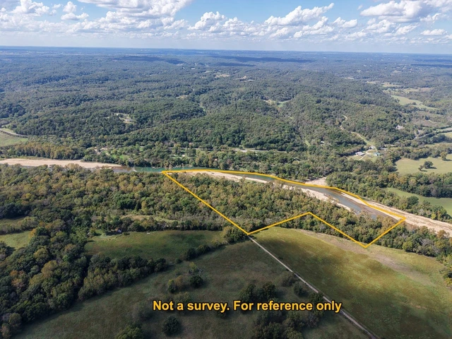
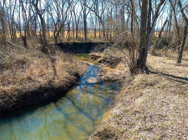
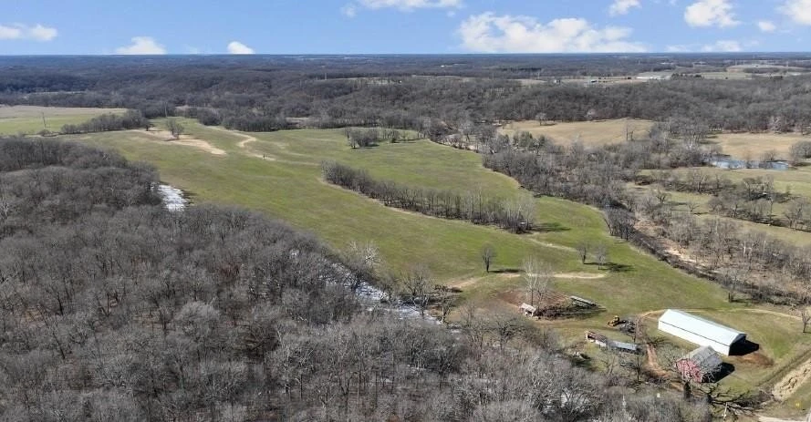
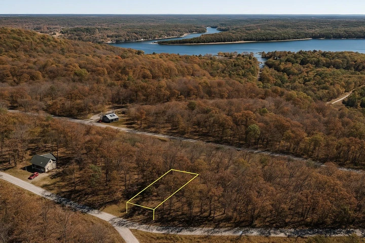
This is the kind of ground that feels like it's been waiting for someone. Seven acres of rolling Ozark foothills in northeastern Mayes County, just five miles from SpavinawMickey Mantle's hometownwith a seasonal creek winding through the property and power already at the road.
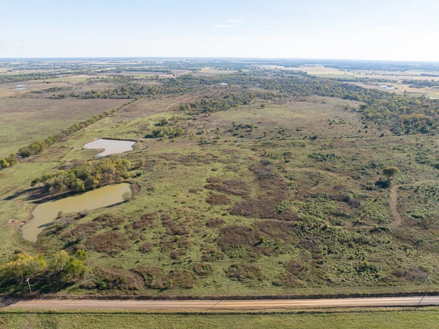
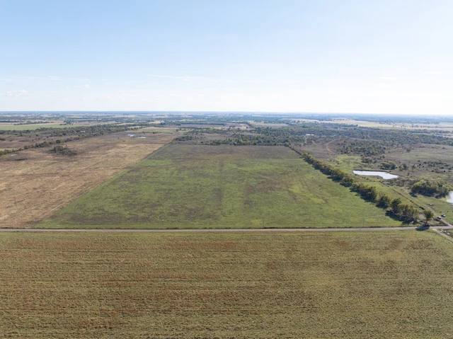
The terrain rolls and drops the way the Ozark fringe does in this part of Oklahoma, where the Cherokee Plains give way to the dissected plateau. Oak and hickory dominate the higher ground, with the bottomland vegetation thickening along the creek corridor. At 654 feet of elevation, you're sitting on the western edge of the Ozark Highlandsthe same rough, timbered country that makes up the nearby 14,000-acre Spavinaw Wildlife Management Area, known for whitetail, turkey, squirrel, and rabbit.
The property is completely unrestricted. Cabin, barndominium, mobile, tiny home, RVwhatever you want to build, you can build. The dimensions are roughly 660 by 427 feet, giving you room to site a structure on the high ground while keeping the creek bottom wild. No HOA. No floodplain. Annual taxes run about $90.
Grand Lake o' the Cherokees46,500 surface acres of bass, crappie, and catfish wateris about 15 miles northeast. Lake Spavinaw and Lake Eucha are even closer, both known for exceptional bluegill fishing and quiet shorelines. Spavinaw State Park is just down the road. Tulsa is an hour west. You're close enough to get what you need, far enough to forget about it when you don't.
This is where the Ozarks begin and the prairie ends. The oaks turn wine-colored in springthat's where the town got its name, from the French traders who came through in the 1700s. Cherokee families settled this creek after the Trail of Tears. The ground has been walked a long time.
Dirt road access off N4460 Road. Power available through Grand River Dam Authority. Well required for water; septic for sewer. Starlink covers the area if you need to stay connected. Warranty deed. Survey not included.
Weekend deer camp, off-grid cabin, place to park the camper and disappear for a whilethis is the kind of small acreage that lets you do what you want without asking permission. Call or text 855-833-5263 to get the details or schedule a walkthrough.
7 Acres, Creek, No Restrictions, Power at the Road
7 unrestricted acres in northeastern Mayes County, OK5 miles from Spavinaw. Dimensions approximately 660' x 427'. Rolling Ozark foothills terrain with seasonal creek on property. Elevation 654 ft; no floodplain. Oak-hickory timber typical of the Ozark Plateau fringe. Power available at the road through GRDA; well and septic required. Mobiles, tiny homes, RVs, barndominiums, and camping all permittedno HOA, no restrictions. Annual taxes $90. Dirt road access via N4460 Rd. Grand Lake o' the Cherokees 15 miles NE; Spavinaw State Park and Lakes Spavinaw/Eucha nearby. Spavinaw WMA (14,000+ acres, whitetail, turkey, squirrel) within 10 miles. Tulsa 55 miles SW. Warranty deed; survey not included. GPS: 36.39522, -95.05862. APN: 0000-10-22N-21E-3-004-00. Call or text 855-833-5263.
Property Information:
Parcel Size:7 Acres
State: Oklahoma
County: Mayes County
Nearest Cities: Spavinaw, OK
Parcel #:0000-10-22N-21E-3-004-00
Address: 00 N4460 Rd, Spavinaw, OK 74366
Legal Description: 10-22N-21E 1283/1003 W429'SWSWSW
Zip Code: 74366
Annual Property Taxes: $90
Agricultural Tax Exemption: No
HOA: No
HOA per Year: None!
Survey Available: No
School District: Spavinaw Public School District
Liens and Back Taxes: None!
Source Deed: Sent for Filing.
Title Status: Free & Clear!
Outgoing Conveyance: Warranty Deed
Property Features:
Acres: 7
Dimension: 660 FT x 427 FT
County: Mayes County
Access: Dirt Road
Power: Available
Water: Well Required, Rain Harvesting, or Alternative
Coordinates: 36.39522, -95.05862
Zoning: Rural
Elevation: 654 FT
Terrain: Rolling
Floodplain: None
Duplexes: Yes
Mobiles: Yes
Tiny Homes: Yes
Barndominiums: Yes
RV's: Yes
Camping: Yes
Utilities:
Power: Grand River Damn Authority
Water: Water well, collection, hauling/delivery, or alternative.
Sewer: Septic or alternative sewer system.
Phone: Landline, Cellular, VOIP (see internet below), and satellite phone through Iridium, Globalstar, or Inmarsat.
Internet: Satellite internet through Starlink, HughesNet, or ViaSat.
Cable: Satellite cable through Dish or DirectTV.
County Contacts:
County Assessor: (918) 825-0625
County Treasurer: (918) 825-0160
County Recorder: (918) 825-2426
County Health: (918) 825-4224
Details
County: Mayes
Zipcode: 74366
Property Type One: Recreational Property
Property Type Two: Residential Property
Property Type Three: Undeveloped Land
Brokerage: Remarkable Land, LLC
Brokerage Link: remarkableland.com
Apn: 00001022N21E300400

Robert Dow
Remarkable Land, LLC
(855) 833-5263
By clicking the button, you agree to our Terms of Use and Privacy Policy.


Nearby Listings
Cherokee County, OK
$4,499,000 - 320 ac.
Adair County, OK
$202,500 - 27 ac.
Craig County, OK
$1,800,000 - 400 ac.
Craig County, OK
$376,000 - 80 ac.
Delaware County, OK

$1,880,000 - 13 ac.
Craig County, OK
$1,150,000 - 98 ac.
Mayes County, OK
$969,000 - 35 ac.
Mayes County, OK
$74,900 - 8 ac.
Benton County, AR
$2,900,000 - 385 ac.
Delaware County, OK
$6,000 - 0 ac.