
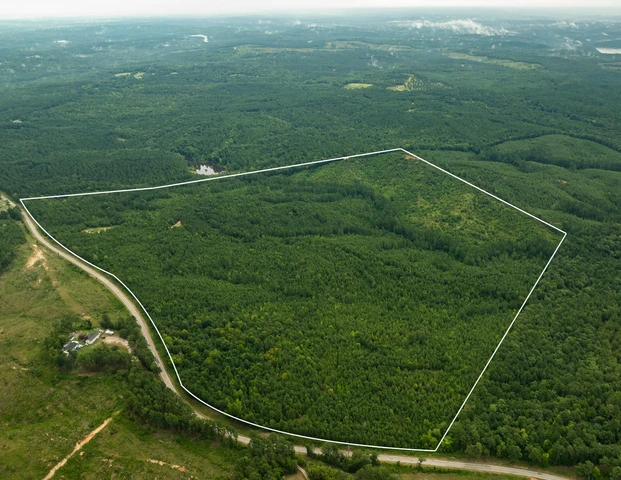
Rodens Creek
Lockhart, SC | Lat/Lng: 34.7581, -81.3952
$501,120
119.31 ac.
04/29/2025
ACTIVE

Description
Rodens Creek Tract is a great timber and recreation property with diversity for wildlife habitat. The land lies east of Mt. Pleasant Church Road just above Hwy 9 between Lockhart and Chester in a quiet, rural area of northern Chester County.
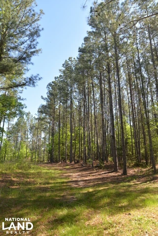
About 85 acres are forested with loblolly pine planted in 2007. These trees are ready for their first thinning. Much of the pine area is gently rolling ridgetops. Side slopes are gentle in some places and steeper in others. Some old gullies are included in the pine area.
Access across the land is good with internal roads that run to the back and center areas. Additional atv/utv trails branch off the truck road. A powerline right-of-way crosses the tract and occupies about 2.5 acres. There are no large open areas apart from the powerline right-of-way.
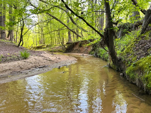
About 25 acres are covered by mixed, mature hardwood forest. This includes the steepest parts of the land with very strong slopes and some gullied areas. These slopes are dominated by oaks, hickory and American beech. Rodens Creek is a large stream with a sandy, gravely bottom that runs the northeast property line for about a quarter mile. The hardwood bottomland along the creek is wide in places. Another broad bottomland is found extending toward the middle of the tract just north of the powerline right-of-way. Yellow poplar, sweetgum, and river birch shade these level bottomlands. Trees are widely spaced, and much of the ground is covered by grasses.
Soils are mostly sandy loam or sandy clay loam and are productive for timber and wildlife openings. Topography is strongly rolling over most of the tract. Some ridge tops and bottomland areas lay gently and would be useful for large wildlife openings. About 50 acres are classed as useful farmland (USDA soil classes for prime farmland). However, these better soils are found in fairly narrow areas along the highest parts of the tract. Thus, a series of openings could be practical but not a single large field. See attached USDA farmland classification map.
Soil maps indicate that septic perc potential is good for the most accessible parts of the property. Topography is gentle near the paved road. A powerline runs along Mt. Pleasant Church Road to serve houses to the north. TruVista has a fiberoptic internet line along the road. There are no public waterlines nearby. The immediate neighborhood is mostly wooded tracts and houses are widely scattered in the area. No houses are within sight of the property along the road frontage. One residence can be seen from the western property line.
The land is accessed from Mt. Pleasant Church Road (State Road 54). The town of Chester is a 15-minute drive away and offers restaurants, doctors, churches, and groceries. There are local favorites like Broad River Mercantile and Nova Donuts Caf, and chains like Ace Hardware and Tractor Supply. The little town of Lockhart is only a stone's throw away. The tract is about 5 miles from Lockhart, 12 miles from Chester, 37 miles from Spartanburg, 30 miles from Rock Hill, and 60 miles from Charlotte. All distances are approximate road miles to the center of town.
The property is timberland with no improvements and does not have an address. It is on Mt. Pleasant Church Road (GPS = State Rd 54, Chester, SC 29706) about 1,000 feet from its junction with Hwy 9. County tax map # 018-00-00-040-000.
Details
County: Chester
Zipcode: 29706
Property Type One: Recreational Property
Property Type Two: Timberland
Property Type Three: Hunting Land
Brokerage: AFM Real Estate
Brokerage Link: AFMRealEstate.com

Philip Weatherford
AFM Real Estate
(864) 238-5372
By clicking the button, you agree to our Terms of Use and Privacy Policy.


Nearby Listings
Newberry County, SC

$459,000 - 67 ac.
Chester County, SC
$999,000 - 263 ac.
Fairfield County, SC
$2,200,000 - 205 ac.
Cherokee County, SC

$3,495,307 - 78 ac.
Cherokee County, SC
$3,495,307 - 78 ac.
Cherokee County, SC
$3,495,307 - 78 ac.
Cherokee County, SC
$3,495,307 - 78 ac.
Cherokee County, SC
$3,495,307 - 78 ac.
Cherokee County, SC
$3,495,307 - 78 ac.
Cherokee County, SC
$3,495,307 - 78 ac.