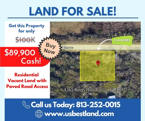
0.40 acres in Brevard County, Florida
4265 Kings Highway, Cocoa, FL | Lat/Lng: 28.4905, -80.7885
$89,900
0.4 ac.
06/11/2026
ACTIVE

Description
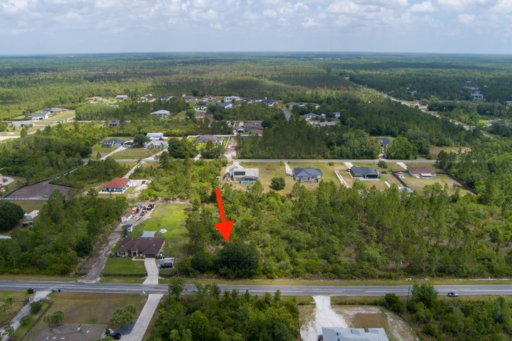
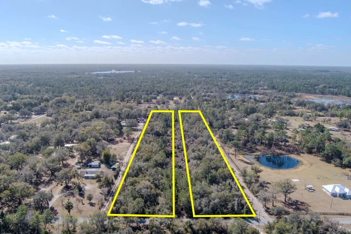
Discover the potential of this 0.40-acre vacant parcel zoned RU-1-11 (Single-Family Residential Zone Lot), allowing for a single-family detached home. This zoning makes the property an excellent opportunity for a custom-built residence or long-term land investment.
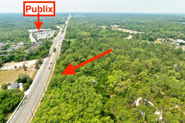
The parcel offers excellent roadside frontage and a natural, untouched setting surrounded by mature vegetation and native Florida landscape. With paved road access, it provides a private and peaceful atmosphere while remaining conveniently connected to nearby amenities and services.
The property features no wetlands, offering a more straightforward path for future development and site planning. Overhead utility lines are already in place along the road, providing added convenience and helping to support future development.
The flat to gently wooded terrain offers flexibility for a well-designed homesite with ample space for privacy and outdoor living. Whether you're looking to build your dream home or secure a long-term investment, this property presents a strong opportunity in a growing area while offering the perfect balance of privacy, accessibility, and natural beauty.
.
You can own this property for just $89,900—offered at 10% below market value. Contact us today to make it yours!
++++ PURCHASING OPTIONS ++++++++++
Cash: You pay only $89,900!
No Seller Financing Available.
++ PROPERTY INFO ++
Parcel # (APN): 23-35-14-JZ-B-27
Legal Description: PORT ST JOHN UNIT 8 THAT PART OF TRACT B LYING IN SECTION 14 AS DESC IN ORB 5561 PG 2748
Parcel Size: 0.4 acres
Approximate Dimensions: 148.4 Ft x 127 Ft x 148.4 Ft x 127 Ft
++ LOCATION ++
Address: 4265 Kings Hwy Cocoa, FL 32927
GPS Center Coordinates:
28.490510, -80.788477
GPS Coordinates (Corners):
28.490712, -80.788745
28.490709, -80.788273
28.490365, -80.788273
28.490356, -80.788753
Driving Directions:
From Orlando, FL, head east on E Anderson St and continue for about 0.5 miles to FL-408 E (East-West Expressway). Merge onto FL-408 E and continue for approximately 9–10 miles. Take FL-417 S (Central Florida GreeneWay) and follow it for about 10–12 miles. Continue onto FL-528 E (Beachline Expressway) and drive for roughly 18–20 miles. Merge onto FL-407 S and continue for about 2–3 miles, then turn onto Shepard Dr and follow for approximately 1–2 miles. Continue onto Grissom Pkwy for about 3–4 miles, then turn onto Kings Hwy. Proceed along Kings Hwy for approximately 1.0 mile, and the destination will be located on the right-hand side.
Elevation: 20 feet
Property Access: Paved road access
++ OTHER PROPERTY INFORMATION ++
Annual Property Taxes: $853.66
Access to Property: Legal and Physical Access
Road Surface Type: Paved road
Terrain Type: Flat
++ NEARBY ++
Closest Major City: Orlando, FL - 44 min (45.3 miles )
Nearby Attractions:
Tom Statham Park - 6 min (2.4 miles)
Space Coast Air Adventures - 4 min (2.7 miles)
Brevard County Enchanted Forest Sanctuary - 7 min (4.6 miles)
Gateway: The Deep Space Launch Complex - 17 min (11.7 miles)
Kennedy Space Center Visitor Complex - 15 min (11.1 miles)
Pine Island Conservation Area - 26 min (18.1 miles)
Manatee Cove Park - 21 min (13.9 miles)
American Space Museum & Walk of Fame - 14 min (9.4 miles)
Sand Point Park - 18 min (10.2 miles)
++ BUILDING / USAGE ++
Zoning: RU-1-11 (Single-Family Residential Zone Lot)
Is the property buildable? Yes
What can be built on the property? Single-family detached home
Is the property in the wetlands? No
++ UTILITIES ++
Water? Well is needed
Sewer or Septic? Septic is needed
Electric? Available but not yet connected
Details
County: Brevard
Zipcode: 32927
Property Type One: Residential Property
Property Type Two: Undeveloped Land
Brokerage: USBestLand
Brokerage Link: usbestland.com

David Hans
USBestLand
(813) 252-0015
By clicking the button, you agree to our Terms of Use and Privacy Policy.


Nearby Listings
Orange County, FL
$149,900 - 1 ac.
Osceola County, FL

$5,500,000 - 1230 ac.
Brevard County, FL

$105,000 - 3 ac.
Osceola County, FL
$489,000 - 2 ac.
Seminole County, FL
$66,000 -
Seminole County, FL
$524,900 - 8 ac.
Osceola County, FL

$6,690,000 - 27 ac.
Seminole County, FL
$379,500 - 7 ac.
Volusia County, FL

$37,900 - 0 ac.
Brevard County, FL

$1,650,000 - 25 ac.