Barrow County, Georgia Land For Sale (24 results)
Want to post your listings on AcreValue? View Listing Plans
AcreValue offers multiple types of land for sale in Barrow County, so if you’re looking for a new ranch, farm, recreational property, hunting ground, developmental property, or land investment you’ve come to the right place. Regardless of what your needs or objectives are for your land, we have a large inventory of available parcels that are updated regularly. Therefore, it’s very likely that we have the perfect parcel that meets all the search criteria & specifications that you’ve been searching for. Additionally, because our land for sale listings are always being updated due to the frequency of land being sold or new land listings being put on the market, make sure that you are checking back with AcreValue regularly for updates. When you find the perfect land parcel and you are ready to take the next steps you can easily connect directly with the listing agent to help you facilitate your land purchase. Browse AcreValue's Georgia land for sale page to find more potential opportunities in Georgia that fit your needs. We wish you the best of luck in finding your next ranch, farm, recreational property, hunting ground, developmental property, or land investment.

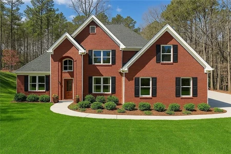
01/07/2026
$1,500,000
43.07 ac.
ACTIVE
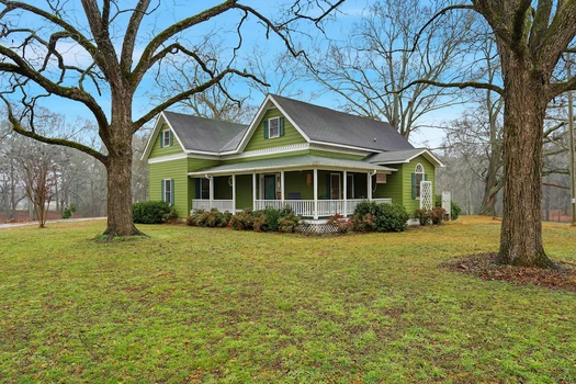
Barrow County - 16 GA Hwy 211, Statham, GA
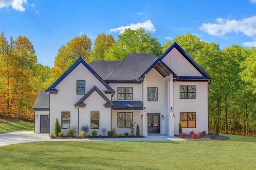
Welcome to a beautiful and versatile 43.07 acre hobby and horse farm in Statham, Georgia, offering the perfect blend of country living, productive land, and well-maintained improvements. This property is ideally suited for those seeking a manageable farm with room to grow, featuring a classic country home, quality outbuildings, open pastures, and natural water features. The farmhouse was originally built in 1906 and completely remodeled in 1997, including new electrical, plumbing, footings, insulation, doors, siding, flooring, sheetrock, and roof. The home offers four bedrooms, 2.5 bathrooms, a bonus room, and oversized closets. Recent updates include central heating and air installed a couple of years ago and updated kitchen countertops. Utilities include city water, four wells located throughout the property, and natural gas and high-speed internet available at the road. The land features approximately 22 acres of open pasture, well-suited for horses or hay production, along with a small creek-fed pond and scenic hardwood draws that add both beauty and privacy throughout the farm. Improvements are well-suited for equestrian or hobby farm use and include a horse barn that formerly housed six stalls and has been used for hay storage, complete with a fully enclosed tack room, two grooming stalls, concrete floors, water, and electric. Additional structures include a workshop with concrete floors, water, and electricity, a metal-sided RV parking structure, multiple sheds, and a corral area. Some fencing is already in place, with infrastructure available to easily add additional fencing as desired. This farm offers a rare opportunity to own a productive and flexible property with room to customize, expand, or simply enjoy a peaceful rural lifestyle within convenient reach of major cities like Athens, Winder, Jefferson, or even Atlanta. Please call Jackson Pryor at 678-544-7098 to schedule a tour. Tours must be scheduled at least 24 hours in advance and buyers must have a pre-approval letter or proof of funds in order to tour the property.


02/25/2026
$37,000
0.87 ac.
ACTIVE
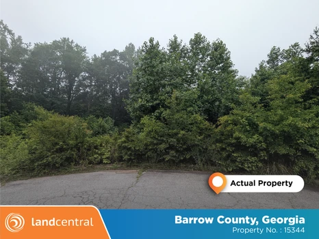
Barrow County - Winder, GA
Seller financing is available on all of our properties. Low down payments, low monthly payments and no credit check. Everyone qualifies.
This 0.87-acre corner property offers a fantastic opportunity for amazing residential development. The spacious lot is ideally located at the end of a small cul de sac while still providing easy access to town. Surrounded by a growing community, the property is close to local amenities, schools, and major highways, ensuring convenience for future owners. Whether you're looking to build a custom home or establish a business, this versatile lot offers the perfect balance of space and location in a thriving area.
Parcel Number: XX053 061
Size: 0.87 acres
Location: Barrow County, GA
Legal Description: All and only that parcel of land designated as Tax Parcel XX053 061 lying and being in the 249th GMD Barrow County Georgia being Lot 27 Westbury Subdivision Unit Two shown in Plat Book 35 Page 205 described in Deed Book 2469 Page 696 the description contained therein being incorporated herein by this reference known as 725 Westbury Court.
Zoning: R-1(Single-Family Residential)
LandCentral Property Number: 15344


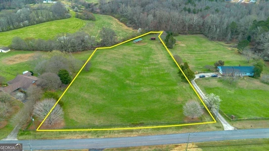
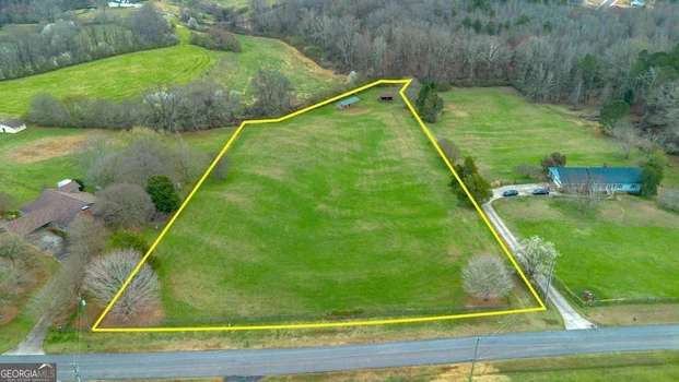
08/30/2024
$2,166,000
28.88 ac.
ACTIVE
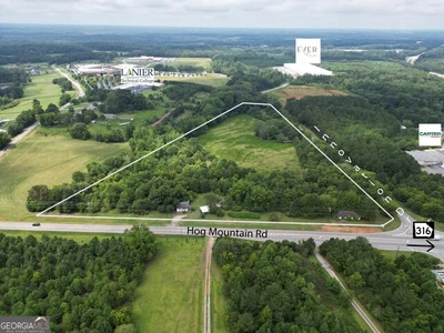
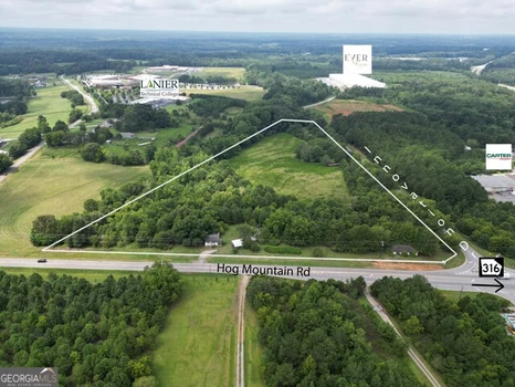
Barrow County - 1442 Bird Hammond Rd., Winder, GA
Unlock the potential of 28.88 acres zoned M1 light industrial, offering unparalleled Build-To-Suit opportunities of up to 322,900 SF. This property is strategically located just 3.5 miles from Barrow County Airport, making it ideal for businesses that require convenient access to air transport. The site also features Rail Re-Load Access to CSX, with existing rail infrastructure available to tenants as needed, enhancing your logistical capabilities. Situated just off GA-316, this property provides easy access to major highways, ensuring seamless connectivity to key markets. Whether youre looking to expand your operations or establish a new facility, this property offers the flexibility and location to meet your business needs. Don't miss out on this exceptional opportunity to position your business for success in a prime industrial hub.


02/15/2021
$5,563,250
20.23 ac.
ACTIVE
Barrow County - 1827 Georgia Highway 211, Hoschton, GA
Property Profile:
Size: 20.23 +/- Acres
Road Frontage: 870 feet +/-
Utilities: Public Water (Sewer Adjacent and may require lift station)
Zoning: General Commercial Town of Braselton
Distinguishing Features: Approximately 8/10 miles from I-85; ample road frontage, good visibility, property has gentle topography.
Beautiful 20.23 acre commercial property located in Barrow County just off I-85 at Exit 126 (Chateau Elan Exit). This area is experiencing explosive growth and this 20+/- acre property is perfect for multiple uses. With 870+/- feet of road frontage and gentle rolling topography this tract has tremendous potential.
Perfect for:
Medical/Office Village
Assisted Living Facility
Higher Density Residential
Age Targeted Development
Who We Are
Advance Land and Timber is a premier, full-service real estate brokerage specializing in timberland tracts, farms, and rural properties across the southeastern United States. With over 23 years of experience and licensure in SC, NC, GA, AL, VA, and MS, we have earned a reputation as trusted industry experts. Our headquarters in Lexington, SC, provide a strategic base to serve clients from Texas to Virginia.


06/12/2025
$1,500,000
6.5 ac.
ACTIVE
Barrow County - 2162 Georgia Highway 211, Braselton, GA
Prime Development Opportunity | 6.5 Acres in Braselton, GA
Offered at $1,500,000 | Zoned R-1 | Future Commercial Potential
Strategically located in the high-growth corridor of Braselton (Barrow County), GA, this 6.5-acre assemblage presents a rare opportunity for future development near some of North Georgias most prominent medical, residential, and commercial anchors.
The property includes four contiguous parcels, currently zoned R-1 (Single-Family Residential), with all utilities available. Surrounded by dense residential rooftops, Class A medical facilities, and just minutes from Northeast Georgia Medical Center, Chateau Elan, and I-85

11/25/2025
$6,000,000
13.47 ac.
ACTIVE
Barrow County - 1211 Hog Mountain Road, Winder, GA
Discover endless potential with this expansive 13-acre commercial property located in the heart of rapidly growing Barrow County. Positioned for visibility and accessibility, the site offers excellent road frontage, level topography, and convenient proximity to major highways, making it ideal for development, investment, or business expansion. Whether you're envisioning retail, industrial, or mixed-use possibilities, this rare acreage provides the space and strategic location to bring your vision to life. surrounded by both residential growth and infrastructure development, it's a standout opportunity in one of Northeast Georgia's fastest-growing regions.


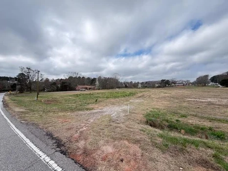
06/28/2023
$1,895,000
7.58 ac.
ACTIVE
Barrow County - Georgia 316, Statham, GA
The property is zoned Light Industrial in the City of Statham which allows a variety of Commercial and Industrial uses. The site was cleared and graded in 2009. There is a detention pond on the rear of the site, and a creek runs along the west boundary line. The site has all utilities available and relatively flat topography. The site is GRAD Certified (Georgia Ready for Accelerated Development).
New Interchange at SR 316 and Hwy 211
GRAD Certified.
High Growth Area


10/27/2025
$899,000
3.82 ac.
ACTIVE
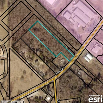
Barrow County - 1129 GA-124, Hoschton, GA
Commercial future property for Auto Repair, Retail, or Restaurant near a major new residential subdivision. Possible c1,2,3 or M-1. All utilities.
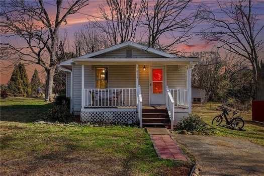
03/19/2026
$315,000
1 ac.
ACTIVE
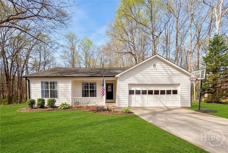
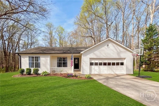
Barrow County - 139 Ashwood Court, Winder, GA
Welcome to 139 Ashwood Ct in Winder where thoughtful design, quality craftsmanship, and peaceful surroundings come together beautifully. Tucked away on a quiet cul-de-sac, this completely remodeled 3-bedroom, 2-bath home sits on a rare 1-acre lot that backs up to a serene creek, offering privacy and a picturesque setting that s hard to find. Inside, you ll immediately notice the attention to detail throughout. The home has been fully renovated the right way, with no corners cut. Enjoy a stunning brand-new kitchen featuring updated cabinetry, modern countertops, new appliances, and stylish fixtures. Fresh paint, new flooring throughout, and updated lighting create a bright, welcoming feel in every room. The open floor plan allows natural light to pour in and makes the home perfect for everyday living and entertaining guests. Large windows frame views of the spacious backyard and bring the outdoors in. Located just minutes from downtown Winder with easy access to Athens, this home offers the perfect blend of convenience and quiet living. For added peace of mind, a pre-listing inspection has already been completed and is available on file for buyers. Homes with this level of renovation and a full acre lot rarely come available schedule your showing today.
03/17/2026
$1,499,900
1.87 ac.
ACTIVE
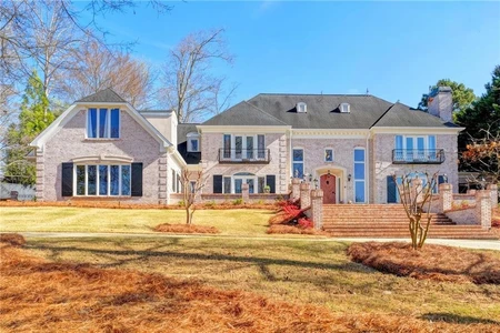
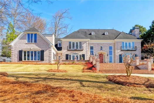
Barrow County - 2035 Derby Lane, Braselton, GA
Spectacular French Country Estate on Two Private Acres in Chateau Elan This stunning all-brick French Country estate is perfectly situated on approximately two private acres within the prestigious gated community of Chateau Elan Winery & Resort. Nestled on a wooded knoll with a circular driveway and elegant courtyard entry, this remarkable home offers exceptional privacy, timeless architecture, and a floor plan designed for both everyday living and grand entertaining. Upon entering, you are welcomed by an impressive foyer highlighted by dual sweeping curved staircases and beautiful custom hardwood flooring throughout the main level. The home is filled with natural light, showcasing expansive windows that overlook the lush grounds and poolside setting. The state-of-the-art gourmet kitchen has been beautifully updated and features granite countertops, newer cabinetry, and premium appliances including double ovens, two dishwashers, a warming drawer, and a Sub-Zero refrigerator. The adjoining breakfast room with stone fireplace and wall of windows opens to a large terrace, creating the perfect indoor-outdoor flow for entertaining. The elegant main level also features a grand salon with breathtaking views of the backyard oasis, a sunken living room, a formal dining room, and a gentleman s study. The luxurious primary suite on the main level offers a private retreat complete with a sitting area, spa-inspired bath, step-in shower, and custom closets. Upstairs, you will find spacious secondary bedrooms, each with a private bath and ample space for family or guests. The finished terrace level is designed for recreation and relaxation and includes a theater/media room, recreation room, exercise room, hobby room, home office, and a stunning brick wine cellar. Step outside to your private outdoor paradise featuring a beautiful 20 x 40 heated gunite pool, expansive decking, and professionally landscaped grounds. The pool house includes HVAC and a full bathroom, making it perfect for guests, entertaining, or a private office. Additional highlights include four fireplaces, custom lighting fixtures, extensive upgrades, and a unique open floor plan ideal for entertaining. As a resident of Chateau Elan, you will enjoy access to world-class amenities including four championship golf courses, the Stan Smith Tennis Center, equestrian facilities, luxury spa, fitness center, swimming pools, restaurants, a 275-room resort hotel, conference center, and miles of walking, jogging, and biking trails. This extraordinary estate offers luxury resort living combined with the privacy of a beautiful two-acre homesite.

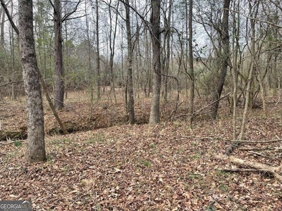
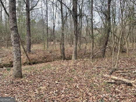
03/19/2026
$179,900
3.57 ac.
ACTIVE
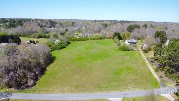
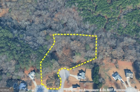
Barrow County - 0 Bear Creek Road CL351468, Statham, GA
Opportunities like this are becoming harder and harder to find. This beautiful 3.57-acre homesite on Bear Creek Road offers the rare chance to build your dream home on land that is already cleared, surveyed, and ready for the next chapter. Unlike many properties that require months of preparation before building can begin, this property gives buyers a significant head start. The land has already been surveyed and successfully perc tested, and the property lines are currently staked, allowing you to easily walk the land and visualize exactly where your future home could sit. The shape and size of the lot offer tremendous flexibility for designing a home with privacy, outdoor living areas, or additional structures while still maintaining a spacious, open feel. With 3.57 acres, you ll have plenty of room to create the lifestyle you ve been dreaming about. Even better, the land has already been cleared, potentially saving thousands of dollars in clearing and grading costs while allowing you to begin planning your build right away. Properties that offer this combination of acreage, build readiness, and flexibility for home placement are increasingly rare in the area. For GPS purposes, the property is located to the left of 2466 Bear Creek e walk the land and imagine what you could create here.
09/27/2025
$2,950,000
7.07 ac.
ACTIVE
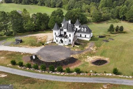
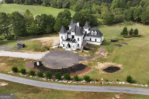
Barrow County - 1197 Dee Kennedy Road, Auburn, GA
HUGE PRICE REDUCTION!! Exciting new progress is being made on this unique Castle "De Kennedy"! Features a huge Owner's Suite, and an abundant flex space to be finished out to buyer's specifications. 2 Upper Levels offers three bedrooms and a game room, all with baths and access to balconies. The transitional areas are still in progress. The home is constructed with ICF concrete reinforced with rebar, making it sound and storm proof, with a high level of construction throughout. The design allows for up to 2 large kitchens and includes a massive unfinished basement that could serve as an entire separate level with additional bedrooms, kitchen, and living areas. Set on 7 beautiful acres with a winding river in the backyard, there is also potential to construct a second smaller home on the property. With many outside balconies and rooftop areas for outdoor enjoyment, this property offers endless possibilities-perfect for a VRBO, event venue, or even a winery. Its location is highly convenient to Chateau Elan and surrounded by large estate homes. Currently, the home is being used as a movie set for the film "Late Night at the Mafia", creating great income for the seller. More pictures to come as completion continues! **Owner financing available at 30% down.


03/12/2026
$659,000
2.05 ac.
ACTIVE
Barrow County - 912 Westwood Lane, Winder, GA
Discover 912 Westwood Lane, a newly completed custom home situated on a generous 2.05-acre lot. This thoughtfully crafted two-story residence combines spacious design with refined finishes throughout every room. A dramatic two-story foyer welcomes you inside and leads directly into the expansive 20-foot great room, highlighted by a striking stone fireplace that sets the tone for the main living area. The kitchen is designed with function and style in mind, offering custom cabinetry, quartz countertops, upgraded lighting, and stainless steel appliances. The home includes 5 bedrooms and 3.5 well-designed bathrooms, providing a balanced layout for both everyday living and hosting guests. A formal dining room sits conveniently off the main level, while the upper-level media loft, complete with a second fireplace, adds a versatile space for entertainment or relaxation. Throughout the home, upgraded trim work, high-quality materials, and detailed craftsmanship enhance each room. Large windows offer natural light and views of the private, park-like backyard, a setting well-suited for outdoor gatherings or future outdoor improvements. This new two-story custom build offers a blend of open space, thoughtful design, and modern finishes across more than two acres. 912 Westwood Lane presents an excellent opportunity to enjoy a spacious property with carefully selected upgrades inside and out.


03/06/2026
$350,000
1.5 ac.
ACTIVE
Barrow County - 1015 Jefferson Highway, Winder, GA
Nestled on approximately 1.5 acres in Winder, this property offers a unique combination of space and versatility with two separate dwellings situated just a short drive from downtown Winder and convenient access to surrounding communities. The main residence features multiple bedrooms and bathrooms with an interior designed for flexible living arrangements. A secondary cottage provides additional living space that can function as a guest suite, home office, or rental opportunity. Inside, both structures offer functional layouts with living and dining areas that flow to practical kitchens. Thoughtful upgrades include durable flooring and traditional finishes that balance comfort with easy maintenance. Bedrooms and bathrooms are well-appointed, providing privacy and everyday convenience. The additional living quarters enhances utility and options for income potential or multi-use living. Outside, the generous lot accommodates ample parking and outdoor space for recreation, gardening, or future enhancements. Both homes are serviced by essential utilities and offer outdoor features such as covered porches/decks perfect for morning coffee or evening gatherings. Located minutes from local shops, dining, and major roadways, this property blends country-like space with everyday accessibility. The dual-dwelling setup presents multiple lifestyle possibilities.

01/09/2026
$795,000
29.1 ac.
ACTIVE
Barrow County - 884 Jackson Trail Road, Winder, GA
Exceptional opportunity on 29+ acres in a highly strategic Winder location with approximately 550 feet of road frontage on Jackson Trail Rd. This versatile tract offers outstanding access to GA-316, I-85, and US-78, placing it conveniently between Athens/UGA, Monroe, and Jefferson, and just minutes to shopping, dining, and major employment corridors. Zoned AG, the property presents multiple potential uses (subject to zoning and county approvals), making it an attractive option for developers, builders, and investors. The land's size and configuration support potential neighborhood development, estate-lot creation, or future commercial/industrial consideration given the proximity to major highways. A creek flows through the property, adding natural appeal and potential for thoughtfully designed layouts. The tract also includes a 2014 Fleetwood mobile home in very good condition, offering immediate use for residence, rental, or site office during planning. Large acreage, strong frontage, excellent accessibility, and long-term upside make this a rare offering in a rapidly growing area. Do not miss this opportunity to secure a sizable, well-located property with multiple paths forward.


11/10/2025
$1,399,000
2.3 ac.
ACTIVE
Barrow County - 1453 Dee Kennedy Road, Hoschton, GA
TO BE BUILT- Luxurious and meticulously crafted, this 5 bedroom 5.5 bathroom custom-built home sits on a sprawling 2-acre private lot fenced and privately gated. Step inside and be captivated by the open floorplan, designed for seamless entertaining. The rich hardwood floors guide you through each room, creating a warm and inviting atmosphere. The main level boasts an oversized owner's suite, a true sanctuary with its own spa-like en-suite featuring a frameless shower, soaking tub, and a generously sized walk-in closet. Host formal gatherings in the elegant dining room or retreat to the large laundry room for added convenience. Aspiring chefs will delight in the chef's kitchen which showcases stainless steel appliances, quartz waterfall countertops, 48in gas range with vented hood, and an oversized kitchen island that effortlessly flows into the living room. Be greeted by soaring 20ft coffered ceiling and built-in bookcases surrounding a cozy fireplace as you enter into the living room. Natural light pours in through expansive windows that reveal breathtaking views of your private backyard oasis. Step outside onto the covered patio offering an outdoor kitchen where endless possibilities await - imagine lounging poolside or hosting unforgettable outdoor gatherings surrounded by lush greenery. Upstairs offers even more space to unwind and entertain with a spacious secondary living room adorned with built-in bookcases and another fireplace. Discover tranquility within the four generously sized secondary bedrooms, offering ample space for relaxation and personalization all offering private bathrooms. The home is conveniently located in close proximity to highway 85, Chateau Elan Winery & Resort, restaurants, and shopping.
03/12/2026
$250,000
5.2 ac.
ACTIVE
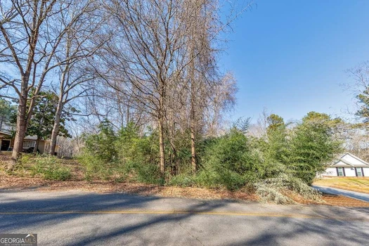
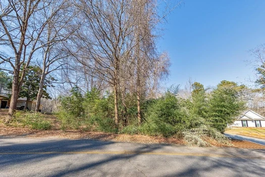
Barrow County - LOT 18 Bear Creek Road, Statham, GA
Great opportunity to build your dream home on this beautiful 5.2 acre lot in Bear Creek Subdivision. The ideal location has so much potential to make this your serene oasis. Gently sloping, fenced lot leads down to a three-stall horse barn with tack room, a hay storage shed and a small creek at the back of the lot. Plenty of room for a pool, entertaining, gardening, etc. Convenient to Athens, Jefferson and Winder areas, recreation, dining and entertainment.


03/13/2026
$185,000
1.39 ac.
ACTIVE
Barrow County - T1 461 Harry McCarty Road, Bethlehem, GA
Picturesque Build-Ready Level Lot ready for your Custom Construction. Bring your own Plans and your Builder or seller will build for you! You get to pick! Amazing location close to Downtown Bethlehem & Winder as well as Lawrenceville, Braselton and Athens! Soil tests already completed. Just decide on what you want to build, pull permits and Build that Perfect home for your family to enjoy or Build to Bring to Market! Total of 3 tracts available at $185,000 each. Tract 1 is approx 1.39 acres, Tract 2 is approx 1.77 acres and Tract 3 is approx 1.64 acres. Will not last long at these prices!


02/12/2026
$94,500
1.95 ac.
ACTIVE
Barrow County - 0 1st Street 10689434, Statham, GA
Discover the perfect place to build your dream home on this beautiful 1.95-acre residential lot just half a mile from charming Downtown Statham. Tucked away for privacy, this serene wooded property offers a peaceful natural setting complete with a creek along the back of the lot - the ideal backdrop for your future home. Enjoy the freedom of no HOA while still benefiting from a convenient location. Experience the best of small-town living with local shops, dining, and community charm nearby, all while being only 15 minutes from Athens and the University of Georgia. Whether you're looking to build now or invest for the future, this picturesque property offers endless potential in a growing and desirable area.


02/12/2026
$94,500
1.95 ac.
ACTIVE
Barrow County - 0 1st Street 7713343, Statham, GA
Discover the perfect place to build your dream home on this beautiful 1.95-acre residential lot just half a mile from charming Downtown Statham. Tucked away for privacy, this serene wooded property offers a peaceful natural setting complete with a creek along the back of the lot the ideal backdrop for your future home. Enjoy the freedom of no HOA while still benefiting from a convenient location. Experience the best of small-town living with local shops, dining, and community charm nearby, all while being only 15 minutes from Athens and the University of Georgia. Whether you're looking to build now or invest for the future, this picturesque property offers endless potential in a growing and desirable area.

03/03/2026
$100,000
3.01 ac.
ACTIVE
Barrow County - 611 Mcdowell Lane, Bethlehem, GA
"Double" lot available in desirable section of Barrow County. Close to area shopping, and Hwy 316. Septic work all done. Ready to pull permits.


12/05/2025
$65,000
0.4 ac.
ACTIVE
Barrow County - 0 E Northcrest Drive 10648147, Winder, GA
Discover the perfect spot for your next build-a private, wooded lot in the heart of Winder. Convenient location with schools just a short walk away, yet tucked back enough to offer peace and privacy. Call today!
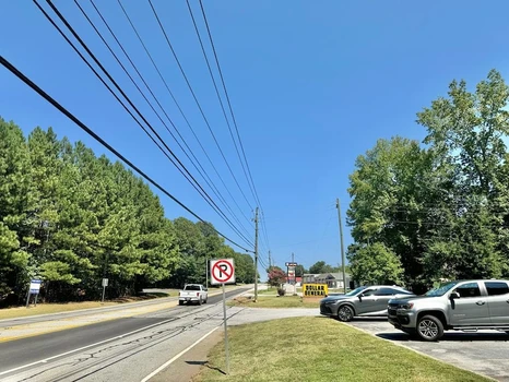
11/20/2025
$650,000
1 ac.
ACTIVE
Barrow County - 00 Atlanta Highway, Auburn, GA
Prime location on US-29 BUS S with 339' feet of highway frontage. This developmental commercial lot consists of 1 acre. Zoning has been approved for gas station. The back of the property is bound by Seaboard Coastline Railroad. Several businesses are already in this high traffic area. The future holds an expansion of the highway which will enhance accessibility. Call list agent Vickie Bateman 912-253-0268 for more info.
NO IMAGES
PROVIDED
PROVIDED
02/22/2026
$369,000
2.94 ac.
ACTIVE
Barrow County - 903 Carl Bramlett Rd, Winder, GA
Private 2.94 Acre lot perfect for your Custom Home or Potentially split for two homes for resale or family compound! Soil tests completed and good perc tests available. Build Ready! Great location just minutes from I-85 and 316 as well as Downtown Winder, GA.


1

